
Top 4 Use Cases of Drone Surveys in Construction
In this article, we look at the uses of drone surveys in construction & civil engineering projects, its benefits, and its integration with Building Information Modeling (BIM).
In the ever-evolving landscape of construction technology, photogrammetry stands out as a powerful tool transforming how we capture, analyze, and utilize spatial data. This technique, which involves obtaining precise measurements from photographs, has found numerous applications on construction sites, improving accuracy, enhancing efficiency, and facilitating better project management.
Understanding Photogrammetry
Photogrammetry is the science of making measurements from photographs. It involves capturing multiple overlapping images of an object or site from different angles and processing them to create accurate 3D models or maps. This technique leverages advanced software to analyze the images and extract spatial data, enabling detailed reconstructions of structures and terrains.
Applications of Photogrammetry in Construction
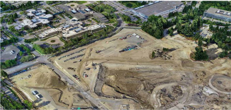
1. Site Surveys and Mapping
One of the primary applications of photogrammetry in construction is site surveying and mapping. Traditional surveying methods can be time-consuming and labor-intensive, whereas photogrammetry allows for rapid data collection over large areas. Drones equipped with high-resolution cameras can capture detailed images of the site, which are then processed to create accurate topographical maps and 3D models.
These models provide allows project stakeholders to perform measurements on the Digital Terrain Model and execute other analytical workflows. In the example above, a drone was used to perform a volumetric analysis on a quarry.
2. Progress Monitoring
Photogrammetry is invaluable for monitoring the progress of construction projects. Regular aerial surveys capture up-to-date images of the site, allowing for comparison with previous captures to track changes and ensure the project remains on schedule. The drone-captured data is processed using specialized BIM software to create highly performant and lightweight meshes. These meshes can be cross-referenced with design BIM models from consultants and architects to detect construction issues.
This real-time monitoring enables the early identification of potential problems, facilitating timely interventions and adjustments to the construction plan.
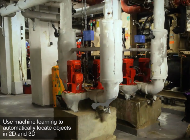
3. AI-enabled Quality Control and Inspection
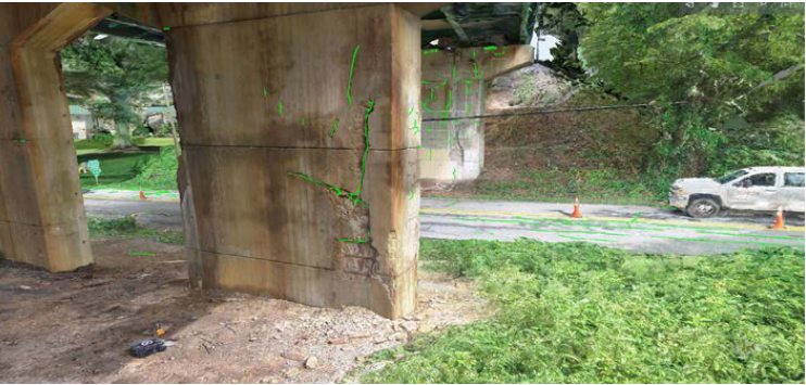
Ensuring the quality and integrity of structures is critical in construction. Photogrammetry offers a non-invasive method for inspecting and assessing the quality of work. High-resolution images can reveal defects, deviations, and inconsistencies that might not be visible to the naked eye. By applying specific AI models to the mesh, workflows such as crack detection, feature extraction, and image recognition can be performed efficiently.
4. As-Built Documentation
The drive towards more energy-efficient buildings is generating increased demand for addition and alteration (A&A) works in Singapore. A crucial workflow for contractors involves documenting existing site conditions to assess the impact of new construction. Photogrammetry provides a straightforward method for capturing detailed records of existing structures on-site. It enables contractors and consultants to simulate and analyze the impact of renovation works, and quickly generate BIM models for value-engineering workflows such as clash detection, site coordination, and BIM for facilities management (FM).
Integrating Photogrammetry with BIM
Building Information Modeling (BIM) is a digital representation of a facility's physical and functional characteristics. Integrating photogrammetry with BIM enhances model accuracy and reliability, offering a comprehensive understanding of the construction project. Specialized BIM software converts drone scans into compressed file formats, enabling BIM engineers to work with photogrammetry data alongside BIM models.
Other Benefits of Drones for Integrated Digital Delivery
Cost Savings
Aerial drone flights can rapidly capture a very large site area with a preconfigured flight path. By minimizing the need for manual surveying and inspections, photogrammetry can significantly reduce project costs when compared to traditional data capture methods like LIDAR. This feature is particularly prized in large-scale civil infrastructure projects where manual surveys are not feasible.
Improve Cash Flow with Progress Claims
The ability to quickly capture and process site data enables customers to track project progress against the design BIM model accurately. This capability is highly valued by contractors, as it allows them to make payment claims based on project milestones. By providing precise and up-to-date visual records, photogrammetry helps streamline the progress claim process, ensuring timely payments and improving overall cash flow for construction projects.
Enhanced Safety
Photogrammetry allows for remote data collection, reducing the need for personnel to physically access hazardous areas. This remote capability enhances safety on construction sites, minimizing the risk of accidents and injuries. By using drones to gather data from difficult-to-reach or dangerous locations, contractors can ensure a safer working environment while still obtaining the detailed information needed for project planning and monitoring
Conclusion
Photogrammetry is revolutionizing the construction industry by providing accurate, efficient, and cost-effective methods for capturing and utilizing spatial data. Its applications in site surveys, progress monitoring, quality control, and as-built documentation are transforming how construction projects are planned, executed, and managed. When integrated with BIM, photogrammetry enhances collaboration, improves data accuracy, and streamlines workflows, driving the industry toward greater efficiency and innovation.
As technology continues to advance, the role of photogrammetry in construction will only expand, offering new opportunities for improving project outcomes and delivering better-built environments. Embracing Scan to BIM workflows is essential for maintaining your competitive edge in this industry.